
Does hiking come to mind when you think about Asheville? Perhaps it never crossed your mind. After all, the vibrant city is primarily renowned for the Biltmore Estate, craft breweries, and a rich arts and cultural scene. If we turn on the fan to blow back the mountain mist, you will discover many rewarding Asheville hiking trails.
Disclosure: This post may contain affiliate links. If you make a purchase through one of these links, I may earn a small commission at no additional cost to you. Thanks for keeping Miles with McConkey going!
Why Should You Visit Asheville?
The eclectic city is easily accessed near Mile 384 on the 469-mile Blue Ridge Parkway, also known as “America’s Favorite Drive.” Asheville offers city and natural attractions, making it a perfect place to camp for part of your journey. The Blue Ridge Parkway connects two national parks, comprising over 200 overlooks and 26 tunnels. You will find Shenandoah National Park on the northern end of the Blue Ridge Parkway, while the southern end runs directly into the Great Smoky Mountains National Park.
Please take this road trip for the ages at a leisurely pace, like savoring your favorite cup of coffee. Make plenty of stops, soak in the scenery, and explore.
The Blue Ridge Mountains and Pisgah National Forest converge in Asheville for a lush landscape where you can hike along forested paths or find treasures like cascading waterfalls and spectacular views across mountains for as far as you can see. If you love tunnels, you can pass through ten of the twenty-six Blue Ridge Parkway tunnels between Miles 364 and 404.
When is the Best Time to Hike in Asheville?
If you have yet to visit Asheville or see the Blue Ridge Mountains, there is no time like now. Asheville welcomes you with wooded trails and striking rock formations within her forested mountains. Although you have an open invitation, North Carolina has designated 2023 as the Year of the Trail, making it the perfect time to explore the Asheville hiking trails.
With lush forests, sprawling mountains, and vast valleys, Asheville hiking yields unique seasonal rewards. Wildflowers typically begin blooming in April, slowly rolling out through summer. Lush green dominates large canvas sections in summer, eventually giving way to crisp red, orange, and yellow hues in autumn. Winter may wrap a white blanket around the rolling mountains, especially in higher elevations. For those who chase waterfalls, spring and fall offer gushing waterfalls. Each season brings something special, and visiting during different times of the year is unique yet rewarding.
Best Asheville Hiking Trails
With so much beautiful scenery, it is challenging to know where to begin. We will outline the best Asheville hiking trails so you can make the most of your adventures in the Blue Ridge Mountains.
Our trail recommendations list covers everything from short, easy hikes to longer, challenging ones. We include hikes with forested trails, waterfalls, and surreal mountain views. Some sit in Asheville, while others require a short drive. Let’s explore the trails.
Craggy Pinnacle Trail
- Location: The trailhead sits near the Craggy Dome parking lot at Mile 364.1 on the Blue Ridge Parkway.
- Distance: 1.2-mile circuit
- Elevation Gain: 250 feet
- Difficulty: Moderate
The Craggy Pinnacle Trail is easily accessed from the Blue Ridge Parkway and offers 360-degree panoramic views of sprawling valleys running between vast rolling mountains. A rhododendron thicket swallows you as you plunge into the path. The beautiful flowers regularly bloom from mid to late June.
Although the trail is short, your climb is steep. When you eventually emerge from the thicket, you will find yourself on a grassy hill with a viewing platform surrounded by a low stone wall. The view is spectacular, a vista of mountains and twisted laurel. Morning fog often nestles in the ridges. Although it may limit your long-range views, the mist has a mysterious beauty. The Craggy Pinnacle Trail regularly provides excellent sunset views.
Note there is a nearby path called Craggy Gardens Trail. It is a lovely hike, but the Craggy Pinnacle viewing platform provides a superior perspective.
French Broad River Greenway
- Location: The trail runs along the French Broad River in the River Arts District (RAD).
- Distance: 3.5 miles
- Elevation Gain: Mostly level
- Difficulty: Easy

The French Broad River Greenway is an easy, mostly level asphalt path that runs through three parks and greenspaces along the French Broad River. You can access the trail at the three parks: Hominy Creek Park, Carrier Park, and French Broad River Park. It is wheelchair accessible, pet-friendly, and accommodates bicycling and inline skating.
Although not a traditional hiking trail, the path delivers lovely views of the river and through the parks. You skirt along the edges of the famous River Arts District, where you can admire art and grab a bite to eat with a craft beverage or delicious coffee.
High Falls Loop
- Location: Dupont State Recreational Forest
- Distance: 1.4 miles
- Elevation Gain: Contains some steep trail sections
- Difficulty: Moderate

Dupont State Recreational Forest is a 50-minute drive from downtown Asheville. The area teems with lush forests and cascading waterfalls, offering many options for hikers. Some of the state park’s most popular attractions include High Falls, Triple Falls, and Hooker Falls. You can hike to each waterfall separately or combine two or all three into one hike. We will break out each of the three hikes separately for our purposes.
Between the woodlands and the waterfalls, the park’s beauty is remarkable. You may feel like you have seen it before. If you are a fan of The Hunger Games or The Last of the Mohicans, filmmakers shot some scenes along these trails.
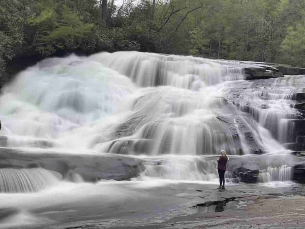
Start at the Dupont State Recreational Forest Visitor Center, where you will find restroom facilities, information, and a picnic area. Trails are well-marked with signs. The High Falls Loop provides an overlook where you gain an excellent perspective of the namesake 120-foot waterfall.
We suggest taking two short spur trails during your journey. The first is called Covered Bridge Trail. You will cross a covered bridge, yielding views from above the falls. Although you can’t look directly at the waterfall from here, it is a lovely view, begging for photographs.
The second spur trail is called Base of the Falls. You get a close view of the falls from below. If water levels are low enough, you can hop along a series of rocks, eventually standing at the base of the falls where you can feel the mist.
Triple Falls Trail
- Location: Dupont State Recreational Forest
- Distance: 0.8 miles round trip
- Elevation Gain: Contains some steep trail sections
- Difficulty: Moderate

The Triple Falls Trail is accessible from either the High Falls Parking Lot or the Hooker Falls Parking Lot. It is a 2.2-mile round-trip hike from the High Falls lot and a 0.8-mile round-trip hike from the Hooker Falls lot.
Triple Falls features a succession of three falls in a relatively tight space. The area consists of many shade trees and pretty rock formations. You can easily enjoy the view while having a snack or picnic lunch along the rocky basin as the falls spill over the edges in the foreground. Although beautiful year-round, the vista typically gets painted in vibrant fall colors in late October or early November.
Hooker Falls Trail
- Location: Dupont State Recreational Forest
- Distance: 0.6 miles round trip
- Elevation Gain: Contains a steep trail section
- Difficulty: Easy to Moderate

Hooker Falls is a brief hike from its namesake parking area, but you earn a close view of the attraction. The short waterfall tumbles down a wide 12-foot-high stair-stepped cliff and spills into a basin surrounded by verdant pines and hardwoods. Admittedly, Hooker Falls is not as spectacular as some other waterfalls in Dupont State Recreational Forest, but something about it exudes beauty and charm, inducing a sense of calm.
Dupont State Recreational Forest has many other trail options. You can combine various loops to customize your experience. We highly recommend these three waterfall hikes. Bridal Veil Falls is another popular hike in the park and is worth exploring.
Black Balsam Hike on the Art Loeb Trail
- Location: About 1 hour south of Asheville at Mile 420 on the Blue Ridge Parkway
- Distance: 2.0 miles round trip
- Elevation Gain: 400 feet
- Difficulty: Easy to Moderate
I love hikes along the Blue Ridge Parkway for three primary reasons:
- You get treated to beautiful scenery every mile of the drive.
- You can quickly locate the trailheads since the entire road has mileposts.
- I am still looking for a hike in the region I want to avoid.
The Black Balsam Hike on the Art Loeb Trail heightens your senses, sparking your body and mind to life. You immediately notice the classic beauty and alluring scent of the Balsam fir trees. After a peaceful stretch through the forest and somewhat rocky terrain, you emerge into a sprawling meadow. It is a glorious sight with mountains on the horizon for as far as you can see.
Wildflowers regularly carpet the field in summer. From late August into autumn, you will likely discover juicy blueberries.
You will ascend to the summit from the meadow, a bald or treeless rocky section with an even better perspective. The setting quickly reminds you why you love hiking.
Bearwallow Mountain
- Location: About 19 miles from Asheville
- Distance: A 1.0-mile trail to the meadow or 0.7-mile gravel access road
- Elevation Gain: 611 feet
- Difficulty: Moderate
The Bearwallow Mountain Trail sits about 30 minutes from Asheville in Hendersonville, North Carolina. With breathtaking panoramic views, including Mount Mitchell, Mount Pisgah, and the Black Mountains, people often describe it as the perfect picnic hike. The journey is steep but rewarding.
You have two options. The trail is a little longer and has steep switchbacks, whereas the gravel access road is shorter with a more gradual incline. You can take the path in one direction and the road in the other if you prefer to try both.
The trail’s summit is a beautiful meadow with long-distance views of the surrounding mountains. You may even spot grazing cows in the summer.
Bearwallow is among the best day hikes near Asheville, with challenging terrain and rewarding views. Be sure to pack a lunch or snack. You will likely want to relax and savor the view.
Biltmore Estate Trails
- Location: 1 Lodge Street, Asheville, NC 28803
- Distance: Offers various trails of different lengths
- Elevation Gain: Varies
- Difficulty: Easy to Moderate

Asheville’s most iconic attraction, the Biltmore Estate, comprises nearly 22 miles of hiking trails through open meadows, lush forests, and the French Broad River. The surreal estate feels like a national park with giant shade trees and extensive flowering plants. Paths throughout the estate yield a rewarding experience due to the surrounding natural beauty. You will encounter a variety of surfaces, including paved, gravel, and dirt trails.
Stroll along the 1.0-mile Azalea Garden Path, where you will discover Bass Pond Waterfall. Historic Gardens is an easy hike with various paths of different distances and surfaces. The area abounds with seasonal blooms, making it a lovely stroll.
Moderate trails include the 3.0-mile Lagoon Trail and the 6.0-mile Farm Trail. More challenging hikes include Westover Trails, Arbor Ace Trail, and Deer Park Trail. Many visitors like the challenge of Deer Park Trail, an uphill climb culminating in a spectacular view of the mansion.
You must have an admission ticket, a Biltmore annual pass, or stay overnight on the property to access the trails.

Graveyard Fields Loop Trail
- Location: About 40 miles from Asheville at Mile 418.8 on Blue Ridge Parkway
- Distance: 3.5-mile loop
- Elevation Gain: 450 feet
- Difficulty: Moderate

Please do not let the name keep you from hiking Graveyard Fields. It is an absolute delight. Although it rained the entire time, Julie and I could not stop smiling. The rain and mist added to the mystique, but the hike was fun.
Graveyard Fields, nestled in a valley below Black Balsam Knob, offers a little bit of everything, including a winding creek, waterfalls, stairs, bridges, forests, and meadows. Rhododendrons brighten the landscape in June, and blueberries ripen mid to late August. It is undoubtedly one of the most popular hikes in western North Carolina.
The trail delivers close views of the waterfalls, which we found pleasantly more extensive and bountiful than we saw in pictures. With beautiful scenery and varied landscapes, the hike is a surefire hit for nature lovers.
Max Patch Trail
- Location: About 40 miles from Asheville
- Distance: 1.5 miles
- Elevation Gain: 430 feet
- Difficulty: Easy to Moderate
A 75-minute drive from Asheville, Max Patch Trail nestles in Hot Springs, North Carolina. The trail’s highlight is its namesake bald upon which the famous Appalachian Trail crosses. Unless you plan to embark on a half-year Appalachian Trail backpacking adventure, it is an excellent opportunity to hike a small section of the iconic trail.
The 1.5-mile loop is a gradual climb where the views are great from the start but get even better as you climb. When you reach the top, you can see the Great Smoky Mountains to the west and the highest peak east of the Mississippi River, Mount Mitchell, to the east. Then it hits you. Max Patch is some of the best hiking on the east coast.
Devil’s Courthouse
- Location: About 37 miles from Asheville
- Distance: 1.0-mile round trip
- Elevation Gain: 272 feet
- Difficulty: Moderate to Difficult
An ominous rocky outcropping calls to you from Mile 422 on the Blue Ridge Parkway. At first glance, it has a sinister face. Some claim that is how it got its name. Others will tell you the devil himself held court in a cave beneath the outcropping. Either way, its name and appearance make the challenge intriguing.
Admittedly, Julie and I have enjoyed many hiking trails with scary names. You can add this one to the list.
Although mostly paved, the trail is steep. The paved path ends with a proverbial fork in the road in a wooded area. The Mountains-to-Sea Trail is to the left. You will stay to the right to continue on the Devil’s Courthouse Trail. When you reach the overlook at 5,720 feet, you can see Georgia, Tennessee, and South Carolina on a clear day.
Grandfather Mountain Trail
- Location: About 70 miles from Asheville
- Distance: 4.8-miles round trip
- Elevation Gain: 800 feet
- Difficulty: Difficult
The Grandfather Mountain Trail is strenuous and challenging. You may hear people call it the chutes and ladders trail. During the trek, you must utilize cable-assisted and ladder access areas. It is the most technical hike east of the Mississippi River without climbing equipment.
Beyond the technical aspects, you must also ascend three peaks:
- McRae’s Peak
- Attic Window
- Grandfather Calloway Peak
Although optional, another trail highlight is the Mile High Swinging Bridge. It is an absolute thrill for some but causes sheer terror for others. The bridge adds 0.3 miles to your journey.
Grandfather Mountain Trail has its rewards but is for experienced hikers. Completing this hike is an accomplishment.
Wrap-Up: Best Asheville Hiking Trails

With so much natural beauty, it is no wonder the Blue Ridge Parkway is “America’s Favorite Drive.” It is a road trip we highly recommend.
With many city and natural attractions and proximity to excellent hiking trails, Asheville is the perfect place to stay and explore the majestic Blue Ridge Mountains. Celebrate North Carolina’s Year of the Trail and find natural treasure in Asheville!
Featured image credit: Miles with McConkey
More Articles from Miles with McConkey