

Julie and I visited Shenandoah National Park for the first time last fall. We were fortunate to arrive around peak foliage to enjoy the gorgeous scenery along Skyline Drive. However, we wanted to explore the park on foot as well.
To our delight, we discovered some fantastic easy hikes. To help you plan your adventures, we will outline 12 easy hikes in Shenandoah National Park, plus three moderate hikes for good measure.
Disclosure: This post may contain affiliate links. If you make a purchase through one of these links, I may earn a small commission at no additional cost to you. Thanks for supporting Miles with McConkey.
Skyline Drive

First, it is essential to note that Skyline Drive runs the entire length of Shenandoah National Park. The famous road starts at the park’s north entrance, Front Royal, and extends to the south gate, Rockfish Gap.
Shenandoah National Park uses mile markers to note the location of points of interest within the park. Skyline Drive is 105 miles long, with mile 0 starting at Front Royal and mile 105 ending at Rockfish Gap.
At Rockfish Gap, Skyline Drive fuses with the equally famous Blue Ridge Parkway. It spans 469 miles, connecting Shenandoah National Park and the Great Smoky Mountains National Park. Both drives offer alluring scenery and many places to explore.
We will list our easy hikes in Shenandoah National Park from north to south and indicate the mile marker for each trail so you know where to find these beautiful hikes.
Hiking Information
Before we cover the list of easy hikes, we need to quickly mention some essential information about hiking in Shenandoah National Park.
Trail Markers & Trail Blazes
Shenandoah National Park does a fantastic job of marking the trails for visitors. You will find trail markers, or posts, at trailheads and intersections.
Each trail marker has a metal band stamped with directional and mileage information. The stamped metal band is at the top of the post.
If you need directions clarification, read the trail marker information to ensure you are going the correct way. Being directionally challenged, we found the trail markers of great value a few times.
Trail blazes, or splotches of paint, are found on rocks and trees throughout the park to help hikers stay on the path. The color identifies the trail type:
- Blue – hiking trail
- White – Appalachian Trail
- Yellow – the course is open to horses
Difficulty
Hiking difficulty scales can be very subjective. The National Park Service assigns trail ratings. All of the trails on our list are rated easy or moderate. We will offer our input where we may disagree.
Generally, trails assigned with an easy grade are less than 3 miles long and are primarily level or have a minor elevation gain. Courses with a moderate rating provide more of a challenge in distance or elevation change.
TRACK Trails
Shenandoah National Park has partnered with Kids in Parks to establish three TRACK Trails where kids can earn prizes for tracking their adventures online and completing activity guides. The idea is to introduce children to outdoor activities and to educate them on taking care of public lands.
Shenandoah National Park houses three TRACK trails:
- Blackrock Summit
- Fox Hollow Trail
- Limberlost Trail
Fully Accessible Trails
Shenandoah National Park has one trail that meets the accessibility definition under the Americans with Disabilities Act (ADA). Limberlost Trail is an ADA-accessible path.
Pets
You can have a leashed dog on most trails in the park. The park has more than 500 miles of trails, and pets are allowed on all except 20 of those miles. Unfortunately, several of the easy hikes do not allow dogs.
The following trails from our list of easy and moderate hikes do not allow pets:
- Fox Hollow Trail
- Stony Man Trail
- Limberlost Trail
- Dark Hollow Falls Trail
- Story of the Forest Trail
- Bearfence Mountain Trail
- Frazier Discovery Trail
If you’re choosing dates for your visit, our guide to the best time to visit Shenandoah can help you pick the season that fits your style.
Easy Hikes in Shenandoah National Park
Here are some of the park’s best easy trails, complete with mile markers and what to expect along the way.
Fox Hollow Trail
- Location: Mile 4.6
- Distance: 1.2-mile circuit
- Elevation Gain: 310 feet
- Difficulty: Easy
You can access Fox Hollow Trail by the Dickey Ridge Visitor Center. It is an excellent opportunity to learn about the park’s cultural history. You will walk along historic rock walls, a cemetery, and lovely periwinkles.
The course is pretty but is more about the history of the park. If your goal is to obtain spectacular mountain or valley views, you will want to choose a different path.
Lands Run Falls
- Location: Mile 9.2
- Distance: 1.3-mile round-trip hike
- Elevation Gain: 325 feet
- Difficulty: Easy
You will find the trailhead at the Lands Run parking area. The fire road trail takes you downhill, where a stream runs beneath the road. Continue following the creek about 25 feet to the right. You will be above a series of cascades that fall into a gorge 80 feet below.
It is an excellent area to explore but is steep, rocky, and slippery by the falls. Use caution and watch your step.
In dry seasons, the waterfall may be nonexistent. Talk to a park ranger before embarking on the hike.
Fort Windham Rocks
- Location: Mile 10.4
- Distance: 0.8-mile round-trip hike
- Elevation Gain: 130 feet
- Difficulty: Easy
Fort Windham Rocks is a short, easy hike from the Compton Gap parking area. You will follow the Appalachian Trail north until you reach the Dickey Ridge Trail, where you will go left. In short order, you will come across two deeply split boulders standing 50 feet tall, eating up the horizon.
Traces Trail
- Location: Mile 22.2
- Distance: 1.7-mile circuit
- Elevation Gain: 333 feet
- Difficulty: Easy
You can locate the trailhead at the Mathews Arm Campground registration parking area. The wooded trail loops around the campground, taking you on a lovely nature hike.
Although you do not obtain mountain views, you see a fantastic section of the gorgeous woods that stretch along the Blue Ridge Mountains. With plenty of vegetation, wildlife sightings are possible.
Stony Man Trail
- Location: Mile 41.7
- Distance: 1.6-mile round-trip hike
- Elevation Gain: 340 feet
- Difficulty: Easy
The hike starts at the Stony Man parking area and takes you along the Appalachian Trail until you reach the Stony Man Trail. From there, follow the trail to the viewpoint where you will overlook the Shenandoah Valley.
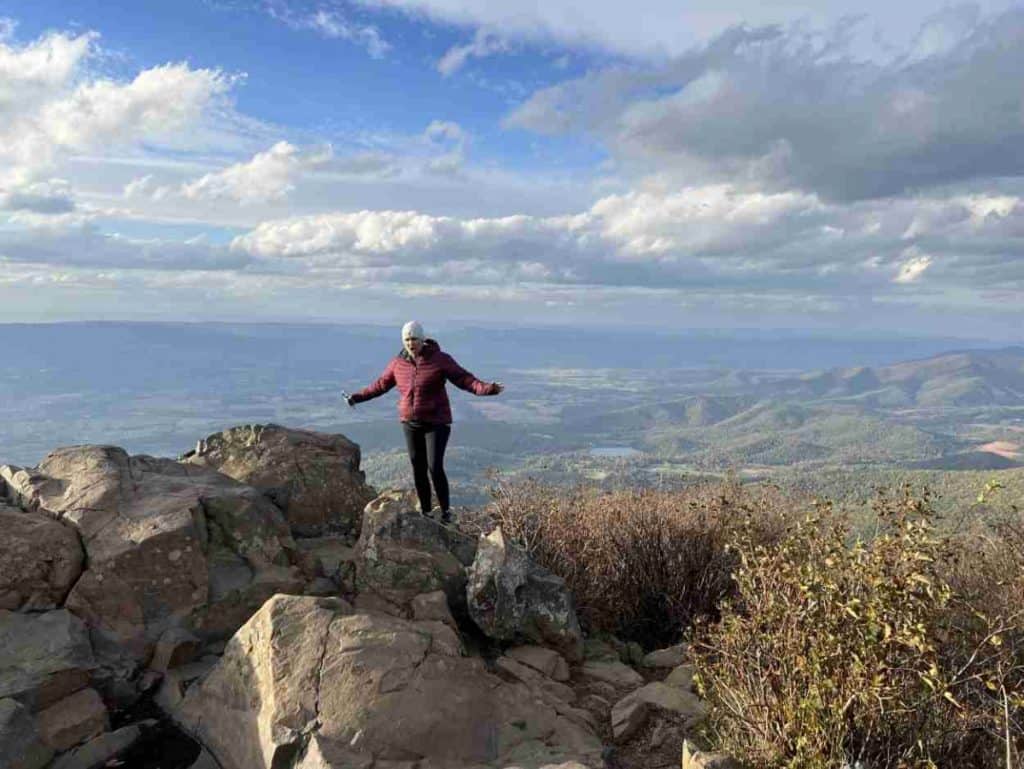
Julie and I loved the Stony Man Trail. A light breeze caused a snowfall of gold leaves as we journeyed toward the glorious panorama.
Skyline Drive offers splendid vistas, but something is rewarding about working to gain an even better vantage point. Stony Man gives you that feeling of satisfaction.
Despite the cold breeze, we could not stop taking pictures of the fantastic view of the valley. It feels like you can see for miles.
Millers Head Trail
- Location: Mile 42.5
- Distance: 1.6-mile round-trip hike
- Elevation Gain: 450 feet
- Difficulty: Easy
The trailhead is up the hill from the Skyland Amphitheater. Millers Head Trail leads you directly to the overlook, a former fire tower surveying the vast valley. Note that the trail is rocky.
The hike is different for two reasons. First, you descend the mountain to the viewpoint, climbing on the return trip. Second, the tower looks over more of the town than the mountains. Although an excellent perspective, you may want another trail if you aim to gaze across mountains.
Limberlost Trail
- Location: Mile 43
- Distance: 1.3-mile circuit
- Elevation Gain: 130 feet
- Difficulty: Easy
You will see the trailhead for the ADA-accessible course at the Limberlost parking area. The greenstone path takes you along a beautiful forested area of the park.
Limberlost Trail is shaded and offers bench seats along the way. One of the highlights is a fantastic boardwalk section lined with mountain laurel that cuts through the forest.
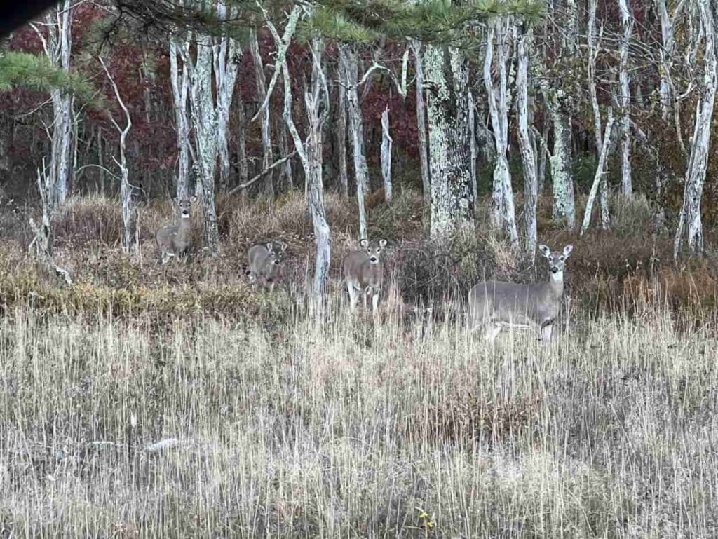
Wildlife sightings commonly occur in the area. Although you do not have views of the valley, it is a lovely walk.
Upper Hawksbill Trail
- Location: Mile 46.5
- Distance: 2.1-mile round-trip hike
- Elevation Gain: 520 feet
- Difficulty: Easy
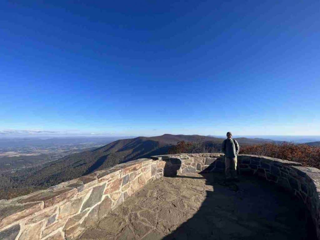
At 4,050 feet, the Hawksbill Mountain summit is the highest point in Shenandoah National Park. As you can imagine, it is a popular area for hikers.
Hawksbill can be confusing because it has three different hikes. The Hawksbill Loop is a moderate 2.9-mile circuit, and Hawksbill Summit is a moderate 1.7-mile round-trip hike. We will focus on the trek with an easy rating, Upper Hawksbill to Hawksbill Summit.
You will find the Upper Hawksbill parking area at Mile 46.5. Follow the Upper Hawksbill Trail until you come across Byrds Nest 2 Shelter, then take that trail to the viewing platform.
Julie and I felt we were on top of the world, looking over the entire Shenandoah Valley and the Blue Ridge Mountains. It is breathtaking due to the outstanding view and the gusty winds. The heartwarming sight easily outweighs the cold wind.
Hiking Upper Hawksbill was one of our most memorable moments in Shenandoah National Park. I feel my heart swell when I think about standing on that platform.
Story of the Forest Trail
- Location: Mile 51
- Distance: 1.8-mile round-trip hike
- Elevation Gain: 290 feet
- Difficulty: Easy
You will access the trailhead by following the sidewalk from the Byrd Visitor Center. It is a lovely stroll on a wooded trail that skirts along the Big Meadow Air Quality Station. The facility is where scientists research Shenandoah’s air quality.
To be more specific, the first half of the trail takes you through the forest, where you connect to a paved bike path for the second half of the hike. The forested section is pretty, especially when wildflowers are in bloom. Deer sightings are somewhat common in the area. Note that you may not bring your pet on the trail.
Bearfence Viewpoint
- Location: Mile 56.4
- Distance: 1.1-mile round-trip hike
- Elevation Gain: 305 feet
- Difficulty: Easy
You will cross Skyline Drive from the Bearfence Parking area, where you will climb steep stairs to access the trail. Turn right onto the Appalachian Trail at the trail post and head south. When you come to a connector trail, head left. You will then go right onto Bearfence Loop Trail. The viewpoint will be just ahead.
Do not fret if the directions sound intimidating. The park does a fantastic job marking the trails to help you find your way.
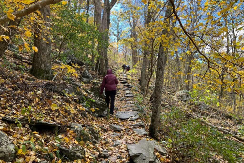
Julie and I enjoyed this hike immensely. The entire path is wooded until the last section leading to the overlook. As we journeyed through the forest, most trees flaunted gold leaves. Some leaves had fallen, making the path feel like the proverbial yellow brick road.
A rugged rock is a natural viewing platform where you have a 180-degree view of the valley. The hike is enjoyable, but the climactic vista brings an even bigger smile.
If you seek more of a challenge, continue straight at the intersection, leading to a rock scramble. Head left onto the connector trail if you fear heights like me. It will be a more enjoyable experience for you.
Frazier Discovery Trail
- Location: Mile 79.5
- Distance: 1.2-mile circuit
- Elevation Gain: 429 feet
- Difficulty: Easy
You will cross Skyline Drive at the Loft Mountain Wayside Parking Area to access Frazier Discovery Trail. The trail is unique, delivering multiple scenic overlooks as you march through woodlands on Loft Mountain.
Although a short hike, the trail is steep. The trail rating is more realistically between easy and moderate, leaning slightly toward moderate. Park staff likely gave the easy rating due to the trail’s short distance.
Blackrock Summit

- Location: Mile 84.4
- Distance: 1.0-mile circuit
- Elevation Gain: 175 feet
- Difficulty: Easy
You can access the trailhead from the Blackrock parking area. Follow the Appalachian Trail south until you come to a trail post. Here you will turn right and proceed to a large boulder field.
Blackrock Summit was our favorite hike. The view is outstanding, and you can scramble to the top of the boulders for an even higher sight. It is a fun and rewarding experience.
I look forward to returning to Shenandoah National Park to complete this hike again.
Moderate Hikes in Shenandoah National Park
Compton Peak
- Location: Mile 10.4
- Distance: 2.4-mile round-trip hike
- Elevation Gain: 855 feet
- Difficulty: Moderate
The Compton Peak hike is memorable for two reasons. First, you trek through a beautiful forest on a section of the Appalachian Trail. Second, you get a close view of a unique geological feature called columnar jointing.
Note the trail is rated moderate, primarily due to the elevation change. If your main goal is to enjoy the view from Skyline Drive but embark on a couple of easy hikes, you may skip this one due to the difficulty rating. You will have opportunities for other short walks with an easy rating.
Dark Hollow Falls Trail
- Location: Mile 50.7
- Distance: 1.4-mile circuit
- Elevation Gain: 440 feet
- Difficulty: Moderate
The trailhead is adjacent to the Dark Hollow Falls parking area. You will follow the stream descending the hill to reach the beautiful waterfall. Although short, the trail is steep and rocky. Your climb on the return hike is challenging.
There are a couple of essential things to note about this hike. First, pets are not allowed on the trail. Second, the waterfall can be lackluster during stretches of dry weather. Before taking the trek, consult a park ranger about the waterfall’s status and recent weather.
Turk Mountain Trail
- Location: Mile 94.1
- Distance: 2.2-mile round-trip hike
- Elevation Gain: 690 feet
- Difficulty: Moderate
You will cross Skyline Drive at the Turk Mountain parking area and head south on the Appalachian Trail to the trail post. Turn right onto the Turk Mountain Trail and follow it to the summit.
Although the park rated the trail as easy, many visitors rated the hike moderate. The track is rocky and steep to the summit. It is more challenging than many other hikes on the list, but it offers an excellent view across the mountainous area.
Wrap-Up: 12 Fun & Easy Hikes in Shenandoah National Park
Viewing the Blue Ridge Mountains along Skyline Drive is a fantastic experience. The park offers an opportunity to explore on foot as well. Take some easy hikes in Shenandoah National Park and enjoy the rewarding views. You will be richer for the journey.
Don’t miss our full guide to Shenandoah!
It’s packed with tips and insights to help you plan a trip you’ll love.