

Sometimes, add-ons are lovely. Admittedly, Guadalupe Mountains National Park was an add-on for Julie and me. Our original plan was to visit New Mexico’s two national parks: Carlsbad Caverns and White Sands. Then, we discovered another national park nearby.
Although located in Texas, Guadalupe Mountains National Park is only 45 minutes from Carlsbad Caverns. We could not pass up this opportunity. Our 8th visited national park provided rugged mountain scenery and some of my favorite hikes across all national parks.
If you love hiking, add this park to your travel bucket list. We cover everything you need to know about this under-the-radar national park so you can plan your Texas-sized adventure in the Guadalupe Mountains.
Disclosure: This post may contain affiliate links. If you make a purchase through one of these links, I may earn a small commission at no additional cost to you. Thanks for keeping Miles with McConkey going!
What is so Special About Guadalupe Mountains National Park?
The park houses Guadalupe Peak, the highest point in Texas at 8,751 feet above sea level. It also comprises a section of Capitan Reef, the world’s largest exposed Permian fossil reef, which is 260 million years old.
Interesting Facts About Guadalupe Mountains National Park

Guadalupe Mountains officially became a national park on September 30, 1972. It spans over 86,000 acres in west Texas and is surrounded by the Chihuahuan Desert.
Although Capitan Reef is a 400-mile-long U-shaped reef, its largest exposed section spans 40 miles, 12 miles within the park.
Guadalupe Mountains National Park receives over 200,000 visitors annually and consistently ranks as one of America’s least-visited parks.
One of the strangest things about the park is the confusion over the time zone. The park is in the Mountain time zone, but cell service comes from towers in the Central time zone. Your electronic devices will likely show the wrong time.
Location
Guadalupe Mountains National Park is in west Texas, about 110 miles east of El Paso and 55 miles southwest of Carlsbad, New Mexico.
The park is accessible by US Highway 62/180, appropriately named the National Parks Highway. It also takes you directly to Carlsbad Caverns.
Operating Hours and Seasons
Guadalupe Mountains National Park is open year-round. While you can use park campgrounds and most trails anytime, park facilities have posted hours, and some areas are day use only.
Fees and Passes
Park admission is $10 per person (age 16+). Your pass is good for seven days, starting from the date of purchase. You can also purchase an annual park pass for $35.
Consider buying an America the Beautiful park pass for $80. This annual pass is valid at all our national parks.
Weather
From May through October, temperatures range from 80 degrees Fahrenheit to over 100. Lows can be between 40 and 60 degrees.
November to April tends to be milder. Highs are between 50 and 70, and lows range from 30 to 50.
Please heed my warning. Guadalupe Mountains National Park is known for being windy year-round, with wind gusts exceeding 60 miles per hour.
During our visit, we experienced 30 to 40-mile-per-hour winds with 60-mile-per-hour gusts. We love hiking, but going against that wind is a challenge! Plus, the “real feel” temperature is considerably lower. Be sure to pack layers and a windbreaker.
Top Things To Do in Guadalupe Mountains National Park
Do not let the outer exterior of rugged mountains and harsh Chihuahuan Desert fool you. The park also has lush streamside woodlands and mountaintop forests. These varied habitats yield unique recreational opportunities.
Hiking
Without question, hiking is the park’s main attraction. You will discover many challenging yet rewarding hikes through rocky canyons, over a series of large boulders, and up iconic peaks.
These hikes will test you, but they are so gratifying. After tackling the rocky trails here, Julie and I felt a great sense of accomplishment. If you enjoy hiking, this park is calling your name!
Below, we outline the hiking trails in each park district.
Birding
Over 300 species of birds nest or migrate here. Regularly sighted birds include canyon towhees, loggerhead shrikes, woodpeckers, roadrunners, and warblers. The best places to spot birds include Frijole Ranch, Smith Springs, McKittrick Canyon, The Bowl, and Pine Springs.
Observing Wildlife
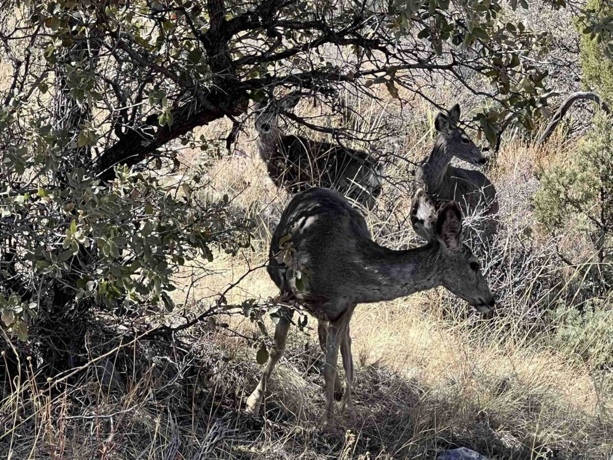
Many different types of wildlife inhabit the Guadalupe Mountains National Park, including mule deer, coyotes, gray foxes, rock squirrels, desert cottontails, and black-tailed jackrabbits. Since most of the park’s animals are nocturnal, spotting them is challenging.
Your best chance to spot wildlife is near sunrise and sunset. Seek out permanent water sources and look for tracks. Manzanita Spring, Smith Springs, and McKittrick Canyon are prime spots.
Please note that black-tailed rattlesnakes and western diamondbacks also live in the park. Mind your surroundings as you hike.
We were fortunate to observe three mule deer feeding close to the Devil’s Hall trailhead. Although near the trail, the deer blended in with the environment and were extremely quiet. I must admit a sharp eye is needed to find them. In our case, it was sheer dumb luck.
Now that we have discussed things to do, let’s discuss the different park districts so you can better plan your adventure.
Park Districts
It is essential to note that the park comprises five districts: Pine Springs, McKittrick Canyon, Frijole Ranch, Dog Canyon, and Salt Basin Dunes.
There are several short spur roads from the National Parks Highway. While these spur roads give you access to park sections, they do not connect to other districts.
One of our biggest challenges when planning this trip was figuring out where to go. With five park districts, we needed to decide where to spend our time. We saw names of trails and destinations, but we needed to determine where to find them.
Here are details on each park district so you can decide where and how to spend your time.
Pine Springs

The park’s hub, Pine Springs, houses the main visitor center and the Guadalupe Mountains National Park headquarters. It is easily accessed by US Highway 62/180.
The visitor center has maps and brochures, and the park store sells souvenirs, books, and other valuable items.
We found the park rangers to be very helpful. After we described our interests, they suggested which trails to hike and provided input on weather and conditions.
I encourage you to talk to a park ranger before setting out on the hiking trails. Knowing current conditions is vital in a region that regularly experiences high winds.
Day Hikes in Pine Springs
- Pinery Trail is an easy, paved 0.9-mile round-trip hike outside the Pine Springs Visitor Center. This path takes you to the Old Butterfield Stagecoach Route Pinery Station.
- Foothills Loop is a moderate 4.5-mile round-trip hike. Plan on 2 to 5 hours. Along the way, you will have a nice view of Bear Canyon and El Capitan. Although not the tallest point, El Capitan is the most pronounced peak on the horizon in Guadalupe Mountains National Park.
- Devil’s Hall is a strenuous 4.2-mile round-trip hike. Plan on 3 to 6 hours. The path starts at Pine Springs Trailhead.
- Guadalupe Peak is a strenuous 8.4-mile round-trip hike. Plan on 6 to 10 hours. Guadalupe Peak is the highest point in the state. As such, you can climb to the “top of Texas” on this trail. The elevation gain is 3,000 feet.
- Hunter Peak is a strenuous 9-mile round-trip hike. Plan on 6 to 10 hours. This hike is a loop up the Bear Canyon Trail and down the Tejas Trail. There is a 2,700-foot elevation change with gorgeous views.
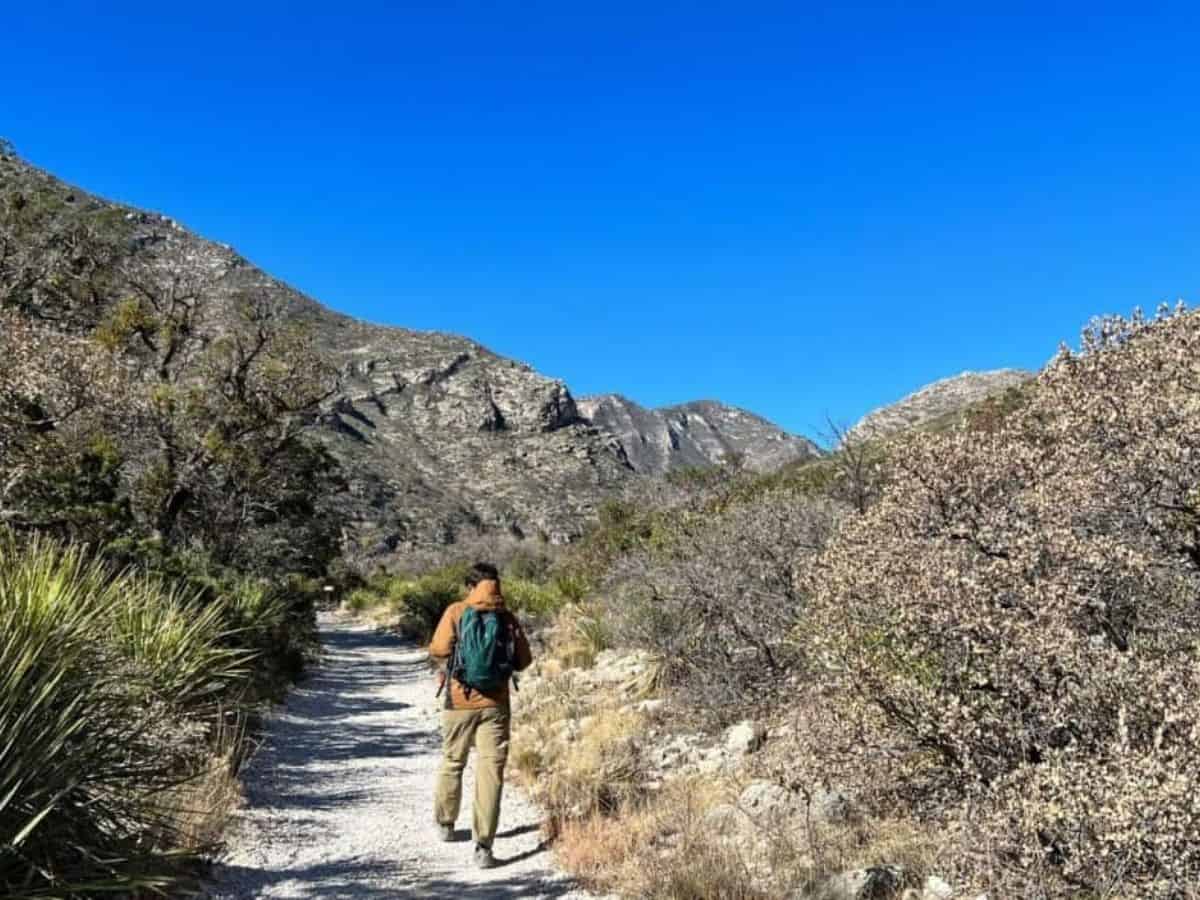
Julie and I hiked Devil’s Hall, one of the park’s most popular hikes. The first half is a rugged but marked path, while the second half takes you along a rocky wash.
You will do quite a bit of bouldering through the wash. Then, you will come to a natural staircase, culminating in a narrow hall between two steep canyon walls.
This hike is a bit of work as you climb the boulders through the wash. However, the “hall” is a nice reward after climbing the staircase.
We enjoyed this hike. Bouldering is a full-body workout that gives you a sense of accomplishment. To this day, I rank Devil’s Hall as one of the most gratifying hikes in any national park.
McKittrick Canyon

You can access McKittrick Canyon from US Highway 62/180. The area is for day use only, and the access gate is locked each evening.
McKittrick Canyon has a small visitor center or “contact station” where you can grab park maps and view outside exhibits.
Julie and I found the rangers in this district to be top-notch, just like at Pine Springs. They offered expert insight into weather and trail conditions.
Day Hikes in McKittrick Canyon
- The Notch is a strenuous 9.9-mile round-trip hike. Plan on 5 to 6 hours. The trail goes through McKittrick Canyon and about halfway up toward McKittrick Ridge.
- Permian Reef Trail is a strenuous 8.4-mile round-trip hike. Plan on 4 to 6 hours. It is a long climb up the north side of McKittrick Canyon to the top of Wilderness Ridge. You get rewarded with fantastic views of the horizon and down into the canyon.
- McKittrick Canyon Nature Trail is a moderate 0.9-mile loop trail of loose rock. Plan on 1 hour. At the top, you will have a view down into McKittrick Canyon.
- The Grotto and Hunter Line Shack is a moderate 6.8-mile round-trip hike. Plan on 4 to 5 hours. There is a mild elevation gain. The Grotto is an exposed cave formation, while the Hunter Line Shack is part of an old 1920s ranch operation. Here, you will find stone picnic tables. After seeing the cave features, you can have lunch or a snack.
- Pratt Cabin is a moderate 4.8-mile round-trip hike. Plan on 2 to 4 hours. The trail crosses a stream and eventually takes you to a cabin. Be sure to sit in a chair on the front porch and enjoy the fantastic view of the mountainous horizon. You earned it!
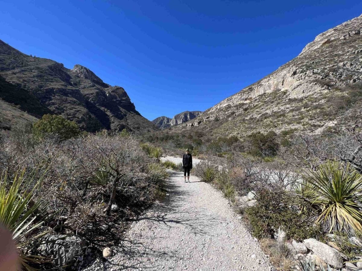
Julie and I hiked to Pratt Cabin. It is a lovely hike with rewarding views from the cabin. During the hike, we faced 30 to 40-mile-per-hour winds with gusts up to 60 miles per hour. For the first half, we were fighting against the wind.
The temperature was in the 40s that morning, so it was cold. Under pleasant conditions, this hike is easy to moderate. However, the winds and temperatures made it more difficult for us.
I recommend this hike due to the spectacular views. However, Julie still has not forgiven me for making her hike in the cold, windy conditions.
Frijole Ranch

Located 1.5 miles northeast of the Pine Springs Visitor Center, Frijole Ranch is accessible from US Highway 62/180 and is open from sunrise to sunset. The district harbors the Frijole Ranch Museum, open when staff is available.
Day Hikes in Frijole Ranch
- Smith Spring Trail Loop is a moderate 2.3-mile round-trip hike. Plan on 1 to 2 hours. The trail takes you to Smith Spring. Most park areas have desert or rugged mountain landscapes. Here, you will find a beautiful pool of water surrounded by vegetation. It seems odd, if not out of place. This location is a literal oasis for wildlife.
- Manzanita Spring is an easy 0.5-mile out-and-back trail. Plan on a half hour to an hour. You will find an expansive pool surrounded by tall grassy vegetation. It is an excellent location for potential bird and animal sightings.
- Foothills Loop is a moderate 4.5-mile round-trip hike. Plan on 2 to 5 hours. This hike also has a trailhead in the Pine Springs district.
Our recommendation for this district is the Smith Spring Trail Loop. It is a nice change of pace to see shade trees and water. Plus, it is one of the best spots to observe birds and animals. Even if you do not see any wildlife, this is a good hike with beautiful scenery.
Dog Canyon
The district sits on the opposite side of the mountain range. Because there are no connecting roads through the park, Dog Canyon requires a two-hour drive from Pine Springs. In full disclosure, we did not visit this section of the park.
Dog Canyon is available 24 hours a day, year-round. The area is more secluded and sits in a forested canyon at an elevation of 6,300 feet. With more solitude, you have opportunities for hiking and birding.
The Dog Canyon Ranger Station is open intermittently. From everything we have seen, it is best to plan for this ranger station to be closed. Staff and volunteers are occasionally in the area.
Day Hikes in Dog Canyon
- Lost Peak Saddle is a moderate 4-mile round-trip hike. Plan on 3 to 5 hours.
- Marcus Overlook is a moderate 5.2-mile round-trip hike. Plan on 3 to 5 hours.
Both of these hikes provide beautiful views south into the Guadalupe Mountains.
Salt Basin Dunes
It is essential to note that Salt Basin Dunes is about an hour’s drive from Pine Springs.
There is no visitor center here. The area is for day use only, and the National Park Service (NPS) prohibits camping in Salt Basin Dunes.
With a clay surface, the access road is slippery and unsafe for vehicles when wet. You will find parking, picnic tables, and pit toilets in Salt Basin Dunes. Water is not available.
The area has a vast landscape of rolling dunes. Sections of white gypsum dunes and red quartz hills can be seen. Rangers ask that you stay on established roadways and trails.
See More National Parks on a Road Trip
Locals asked if we were making the loop. Yes, we are!
We already discussed two parks being near one another. There is a third national park nearby. You can complete the loop, too. Each park is unique and offers something very different.
Carlsbad Caverns National Park, located in Carlsbad, New Mexico, is 45 minutes from Guadalupe Mountains National Park. Best of all, you can access it from US Highway 62/180. The enormous underground caves are mind-blowing! It is one of my favorite national parks.
White Sands National Park, located in Alamogordo, New Mexico, is about 3 hours away. It is a massive field of rolling dunes where you can play, hike, and go sand sledding.
To this day, the loop is one of my favorite travel memories. Although close in proximity, these parks could not be more different in what they offer. I love them all.
Where to Stay
Carlsbad, New Mexico, is a great place to stay. There are plenty of hotels at reasonable rates, and the city has many restaurants and things to do.
We stayed at Hampton Inn & Suites Carlsbad. The hotel has clean rooms, a hot breakfast, and friendly service.
It is the perfect home base for the Guadalupe Mountains and Carlsbad Caverns. You can reach Carlsbad Caverns in about 25 minutes and Guadalupe Mountains in an hour.
Just pull out of the hotel parking lot and follow the signs for the parks. We did not need a map or a GPS. I usually find driving stressful, but the drive from here is well-marked and relaxing.
Tips for Visiting Guadalupe Mountains National Park

Even though it is under the radar, Guadalupe Mountains National Park should be on your travel bucket list.
Here are essential tips to make the most of your Texas-sized adventure.
- Before your visit – Monitor the park website for information and current updates.
- Decide which park districts you plan to visit – Pine Springs, McKittrick Canyon, and Frijole Ranch are all close. Pine Springs is considered the central hub. Dog Canyon sits in a forested canyon and offers more solitude, but it is two hours away. Salt Basin Dunes offers rolling dunes but is an hour away. We spent two days in the park, hiking in Pine Springs, McKittrick Canyon, and Frijole Ranch. If you plan to include either Dog Canyon or Salt Basin Dunes, you will likely need another day or two.
- Choose which hikes you plan to take —The park offers many great hikes, but some will take up most of the day.
- Wear light layers and a windbreaker —The park’s reputation for being windy is real. Do not underestimate the impact of the wind. Pack accordingly.
- Wear hiking boots —Many of the trails are rugged and contain rocks. Some of the courses require bouldering. You will need good traction and support.
- Fuel up before going to the park —The closest gas station in either direction is 35 miles away, so be sure you have plenty of gas in the tank.
- Bring food and water—No gas stations or stores are near the park, so there is no real opportunity to grab supplies. Be sure to pack water and healthy snacks before you hit the trails.
- See it firsthand —Watch our video to see Devil’s Hall and get more travel tips.
We hope you enjoy the park as much as we did. Never stop exploring!
Featured image credit: Miles with McConkey